Herm |
|
|
|
| Übersicht – Contents: | |
Diese Seite ist Teil des Projektes
Herm |
|
|
|
| Übersicht – Contents: | |
Flagge – Flag: |
|
 |
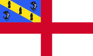
seit/since 1953 Flagge von Herm – flag of Herm, Seitenverhältnis – ratio = 3:5, Quelle/Source, nach/by: Wikipedia (EN) |
historische Flagge – historical Flag: |
|
 |
1950–1953, Flagge von Herm – flag of Herm, Seitenverhältnis – ratio = 3:5, Quelle/Source, nach/by: Wikipedia (EN) |
| Die Insel
Herm verwendet die Flagge Englands, rotes Georgskreuz auf weißem Grund, mit
der Wappenflagge der Insel in der Oberecke. Diese ist blau mit einem gelben
Diagonalstreifen. In dem Streifen sind drei schwarze Silhouetten
von Mönchen zu sehen. Sie stehen für die Missionare St. Magloire, St. Sampson und St. Helier, die zwischen dem 6. und 9. Jahrhundert die Normannischen Inseln christianisierten. In den blauen Feldern ist je Delphin zu sehen. |
Herm Island applys the flag of England, the red St. George's cross on white background, with the escutcheon-flag of the island in the upper left staff corner. It is blue with a yellow diagonal stripe. The stripe contains three black silhouettes of monks which represent the missionaries St. Magloire, St. Sampson and St. Helier, who converted the population of the Norman Islands between the 6th and 9th century to Christianity. Each blue field shows a dolphin in it. |
| Quelle/Source: Wikipedia (EN) | |
| Wappen – Coat of arms: | |
 |
Wappen von Herm – coat of arms of Herm, Quelle/Source, nach/by: Wikipedia (EN), See page for author, CC BY-SA 3.0, via Wikimedia Commons |
| Das Wappen ist blau mit einem gelben Diagonalstreifen. In dem Streifen sind drei schwarze Silhouetten von Mönchen zu sehen. Sie stehen für die Missionare St. Magloire, St. Sampson und St. Helier, die zwischen dem 6. und 9. Jahrhundert die Normannischen Inseln christianisierten. In den blauen Feldern ist je ein Delphin zu sehen. Das Wappen und die Flagge wurden 1953 vom britischen Vexillologen William Crampton geschaffen. | The coat of arms is blue with a yellow diagonal stripe. The stripe contains three black silhouettes of monks which represent the missionaries St. Magloire, St. Sampson and St. Helier, who converted the population of the Norman Islands between the 6th and 9th century to Christianity. Each blue field shows a dolphin in it. The coat of arms and the flag have been created in 1953 by the British vexillologist William Crampton. |
| Quelle/Source: Wikipedia (EN) | |
| Landkarten – Maps: |
Lage
– Position: |
Landkarte
des Landes – Map of the Country: |
Landkarte der Kanalinseln – Map of the Channel Islands: |
| im Norden Alderney, im Süden Jersey, im Westen Guernsey, östlich davon Herm und Sark – in the north Alderney, in the south Jersey, in the west Guernsey, eastern of it Herm and Sark |
|
|
| Zahlen und Fakten – Numbers and Facts: | |
|
|
|
|
|
|
|
|
|
|
|
|
|
|
|
|
|
| ca. 600 v.Chr. · keltische Besiedlung 56 v.Chr. · zum Römischen Reich 511 · zum Frankenreich 843 · zum Westfränkischen Reich 880 · zum Königreich Frankreich 933 · zum Herzogtum Normandie 1066 · Wilhelm I. (der Herzog der Normandie) wird zum König von England gekrönt, damit kommen die Kanalinseln nominell an die englische Krone 1106 · König Heinrich I. von England (Sohn von Wilhelm I.) besetzt die Kanalinseln, löst sie somit vom Herzogtum Normandie ab, und bindet sie an England 1940–1945 · vom Deutschen Reich besetzt |
| ca. 600 B.C. · Celtic settlement 56 B.C. · to the Roman Empire 511 · to the Frankish Empire 843 · to the West Frankish Empire 880 · to the Kingdom of France 933 · to the Duchy of Normandy 1066 · William I. (Duke of the Normandy) gets crowned to the King of England, therewith come the Channel Islands nominally to the English crown 1106 · King Henry I. of England (son of William I.) occupies the Channel Islands, separates them therewith from the Duchy of Normandy, and binds them on England 1940–1945 · occupied by the German Empire |
| Translator of the English text: Joachim Nuthack |
| Quelle/Source: Atlas zur Geschichte, Wikipedia (DE), Discovery '97 |