Moskitoküste |
|
|
|
| Übersicht – Contents: | |
Diese Seite ist Teil des Projektes
Moskitoküste |
|
|
|
| Übersicht – Contents: | |
| Flagge – Flag: | |
| Die Moskitoküste hat keine eigene Flagge (mehr). Das Land ist aufgeteilt zwischen Honduras und Nikaragua, und innerhalb Nikaraguas weiter in die zwei autonomen Regionen Costa Caribe Norte und Costa Caribe Sur. Offiziell wird hier die Flagge Nikaraguas verwendet. Die beiden autonomen Regionen haben ihre eigenen Flaggen. | The
Mosquito Coast has not (more) an own flag. The country is divided between
Honduras and Nicaragua, and within Nicaraguas further in the two autonomous
regions Costa Caribe Norte and Costa Caribe Sur. Officially
is here in use the flag of Nicaragua. The two autonomous regions have their own flags. |
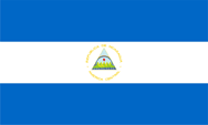 |
Nikaragua – Nicaragua: National-, Staats-, Handels- und Marineflagge – national, state, merchant and naval flag, Seitenverhältnis – ratio = 3:5, Quelle/Source, nach/by: Flags of the World   |
 |
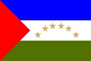
Región Autónoma de la Costa Caribe Norte: Flagge der autonomen Region – flag of the autonomous region, Seitenverhältnis – ratio = 3:5, Quelle/Source: Vrysxy, CC BY-SA 3.0, via Wikimedia Commons |
 |
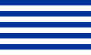
Región Autónoma de la Costa Caribe Sur: Flagge der autonomen Region – flag of the autonomous region, Seitenverhältnis – ratio = 2:3, Quelle/Source: Vrysxy, Public domain, via Wikimedia Commons |
 |
Moskitoküste – Mosquito Coast Flagge der Nationalbewegung – flag of National Movement, Seitenverhältnis – ratio = 3:5(?), Quelle/Source, nach/by: Flags of the World |
historische Flaggen – historical Flags: |
|
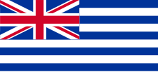 |
1834–1860, Flagge des Königreichs Moskitoküste – flag of the Kingdom of Mosquito Coast, Seitenverhältnis – ratio = 1:2, Quelle/Source, nach/by: Flags of the World |
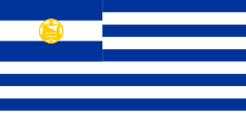 |
1860–1894(?), Flagge des Königreichs Moskitoküste (Variante) – flag of the Kingdom of Mosquito Coast (variant), Seitenverhältnis – ratio = 1:2, Quelle/Source, nach/by: Flags of the World |
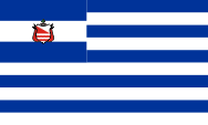 |
1860–1894(?), Flagge des Königreichs Moskitoküste (Variante) – flag of the Kingdom of Mosquito Coast (variant), Seitenverhältnis – ratio = 3:5(?), Quelle/Source, nach/by: Flags of the World |
| Die Flagge zeigte grundsätzlich blaue und weiße Streifen, und im Obereck die Flagge der jeweiligen Schutzmacht (bis 1860 Großbritannien, ab 1861 Nikaragua). | The flag showed in principle blue and white stripes and in the upper staff quadrant the flag of the respective protection power (to 1860 United Kingdom, since 1861 Nicaragua). |
| Quelle/Source: Volker Preuß | |
Wappen – Coat of Arms: |
|
 |
Wappen des Königreichs Moskitoküste – coat of arms of the Kingdom of Mosquito Coast, Quelle/Source, nach/by: Flags of the World |
| Lage der Moskitoküste – Position of the Mosquito Coast: |
| interaktive Landkarten – interactive Maps: |
|
|
| Landkarte/Map: Volker Preuß |
| Zahlen und Fakten – Numbers and Facts: | |
|
|
|
|
|
|
|
|
|
|
|
|
|
|
|
|
| 1502 ·
Kolumbus entdeckt die Moskitoküste 1523 · erfolgloser Versuch der spanischen Eroberung und Kolonisierung durch Hernández de Córdoba, die Moskitoküste erweist sich als schwül, heiß und sumpfig, die Moskito-Indianer leisten erbitterten Widerstand 1535 · Errichtung des Vizekönigreiches Neuspanien, dem Mittelamerika (und damit auch die Moskitoküste) als "Generalkapitanat Guatemala" angeschlossen wird 1630 · erste britische Besiedlung an der Küste 1655 · die Moskito-Indianer unterstellen sich zur Wahrung ihrer Unabhängigkeit gegenüber Spanien britischem Schutz, gehen aber auch Allianzen mit Piraten ein, die diese Küste als Schlupfwinkel nutzen (Bukanier) 1661 · Gründung des Königreichs Mosquitia (Königreich der Moskito-Indianer) 1668 (nach anderen Quellen 1678) · Großbritannien unterstellt das Königreich Mosquitia offiziell seinem Schutz 18. Jhd. · der Schutz des Königreichs Mosquitia wird von Britisch-Honduras aus gewährleistet 1787 · Abzug der britischen Truppen 1789–1800 · Versuche spanischer Besiedlung an der Küste 19. Jhd. · Spanien, USA, Honduras und Nikaragua erheben Ansprüche auf die Moskitoküste 1841 · Erneuerung des britischen Protektorats über das Königreich Mosquitia 1848 · das Königreich Mosquitia erobert mit britischer Unterstützung die Ortschaft San Juan del Norte (Greytown), die Ortschaft wird wegen Protesten der USA – die ihre Interessen an einem interozeanischen Kanal gefährdet sehen – an Nikaragua abgetreten 1850 · Clayton-Bulwer Vertrag zwischen Großbritannien und USA, beide Länder verzichten auf weitere territoriale Erwerbungen und garantieren die Neutralität eines künftigen interozeanischen Kanals, Großbritannien muss sein Protektorat über Mosquitia beenden 1859 · Großbritannien übergibt sein Protektorat über das Königreich Mosquitia an Honduras, Aufstände unter den Moskito-Indianern 28.01.1860 · Vertrag von Managua, Großbritannien übergibt das Protektorat Königreich Mosquitia an Nikaragua bei Garantie von dessen weiterer Autonomie, Honduras behält die Teile der Moskitoküste nördlich des Rio Coco 1864 · Nikaragua erkennt den König von Mosquitia nicht mehr an und versucht sich in die Belange der Moskitoküste einzumischen, es kommt in den Folgejahren zu Spannungen 1880 · der Kaiser von Österreich, der als Schiedsrichter bestimmt wurde, bestätigt die Rechte der Moskito-Indianer 06.07.1894 · der Präsident Nikaraguas José Santos Zelaya lässt Truppen der USA in Bluefields einmarschieren 20.11.1894 · die Moskito-Indianer verzichten "freiwillig" auf ihre Autonomierechte, das Königreich Mosquitia endet und die Moskitoküste wird als Departemento Zelaya dem Staat Nikaragua angegliedert, die Moskito-Indianer bewahrten jedoch bis heute ihre Kultur und Sprache (Englisch) 1960 · der Internationale Gerichtshof bestätigt den Besitz von Honduras an Teilen der Moskitoküste, Beendigung der Grenzstreitigkeiten zwischen Honduras und Nikaragua 1987 · Nikaragua gewährt der Moskitoküste wieder eine eingeschränkte Autonomie, jedoch wird das Land in zwei Regionen aufgeteilt: Región Autónoma de la Costa Caribe Norte und Región Autónoma de la Costa Caribe Sur |
| 1502 ·
Columbus discovers the Mosquito Coast 1523 · unsuccessful attempt of Spanish conquest and colonization by Hernández de Córdoba, the Mosquito Coast proves as sultry, hot and swampy, the Mosquito Indians do embittered resistance 1535 · establishment of the Vice Kingdom of New Spain, which Central America (and therewith de facto the today's Mosquito Coast) gets affiliated as "General Capitanate of Guatemala" 1630 · first British settlement near the coast 1655 · the Mosquito Indians subordinate themselves the British protection for perpetuation of their independence against Spain but make also alliances with pirates which use that coast as hideout (Buccaneer) 1661 · establishment of the Kingdom of Mosquitia (Kingdom of the Mosquito Indians) 1668 (by other sources in 1678) · United Kingdom subordinates officially the Kingdom of Mosquitia its protection 18th cent. · the protection of the Kingdom of Mosquitia is ensured from British-Honduras 1787 · withdrawal of the British troops 1789–1800 · attempts of Spanish settlement near the coast 19th cent. · Spain, USA, Honduras and Nicaragua claim the Mosquito Coast 1841 · renewal of the British protectorate over the Kingdom of Mosquitia 1848 · the Kingdom of Mosquitia captures with British support the town San Juan del Norte (Greytown), the place becomes ceded to Nicaragua because of protests of the USA which saw endangered its interests in an interoceanic canal 1850 · Clayton-Bulwer Treaty between United Kingdom and the USA, both countries renounce for further territorial purchasea and guarantee the neutrality of a coming interoceanic canal, United Kingdom has to terminate its protectorate over Mosquitia 1859 · United Kingdom tranfers it protectorate over the Kingdom of Mosquitia to Honduras, riotings under the Mosquito Indians 28th of January 1860 · Treaty of Managua, United Kingdom transfers the Protectorate over the Kingdom of Mosquitia to Nicaragua in guaranty of its forth autonomy, Honduras keeps the parts of the Mosquito Coast northern the Coco River 1864 · Nicaragua recognizes no more the King of Mosquitia and attempts to interfere the affairs of the Mosquito Coast, in the following years arise riots 1880 · the Emperor of Austria which was destined as arbitrator confirms the rights of the Mosquito Indians 6th of July 1894 · the President of Nicaraguas José Santos Zelaya lets invade troops of the USA in Bluefields 20th of November 1894 · the Mosquito Indians renounce "voluntary" for their autonomy rights, the Kingdom of Mosquitia ends and the Mosquito Coast becomes annexed to Nicaragua as Departemento Zelaya, but the Mosquito Indians preserve until today their culture and language (English) 1960 · the International Court of Law confirms the ownership of Honduras in parts of the Mosquito Coast, termination of the frontier quarrels between Honduras and Nicaragua 1987 · Nicaragua grants the Mosquito Coast a limited autonomy again, but the country becomes divided in two regions: Región Autónoma de la Costa Caribe Norte and Región Autónoma de la Costa Caribe Sur |
| Quelle/Source: Atlas zur Geschichte, World Statesmen, Wikipedia (EN) |
| Der Name "Moskitoküste" hat mit Insekten nichts zu tun. Er ist abgeleitet vom Stamm der Miskito-Indianer, die zur Nation der Chibcha-Indianer gehören. Im Laufe der Jahrhunderte gab es bei den Miskito eine starke Durchmischung mit entflohenen schwarzen Sklaven und deren Nachfahren, so dass sie sich heute mit einer sehr dunklen Hautfarbe präsentieren. Ihr Königreich nannten die Miskito "Mosquitia". Von den Spaniern wurden und werden sie "Mosquito" oder "Misquito" oder nur "Mosco" genannt. Die Engländer nennen und nannten sie "Mosquito", eine Bezeichnung die heute allgemein gebraucht wird. | The name
"Mosquito Coast" has nothing to do with insects. It has its roots in the
name of the tribe of the Misquito Indians which belong to the nation of the
Chibcha Indians.
In the course of the centuries there was at the Misquito a potent mixture
with escaped black slaves and their descendants, so that they are represent
themselves today with a very dark skin color. Their kingdom the Misquito
named "Mosquitia". By the Spanish they were and they are named "Mosquito" or
"Misquito" or just "Mosco". The English named and name them "Mosquito", a
denomination which is today generally in use. |
| Quelle/Source: Handbuch der geographischen Namen, Wikipedia (DE), Volker Preuß | |