Austral-Inseln |
|
|
|
| Übersicht – Contents: | |
Diese Seite ist Teil des Projektes
Austral-Inseln |
|
|
|
| Übersicht – Contents: | |
Flaggen – Flags: |
|
 |
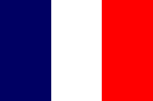
die Flagge
Frankreichs |
 |
seit /since 1984,    |
|
|
|
inoffizielle Flagge – unofficial Flag: |
|
 |
inoffizielle Flagge – unofficial flag, |
|
|
|
|
Die Austral-Inseln – als Teil von Französisch-Polynesien
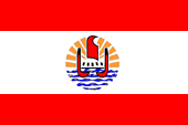
– haben offiziell keine eigene Flagge. Es muss die französische Trikolore
oder zusätzlich die Flagge von Französisch-Polynesien gehisst werden. Jedoch
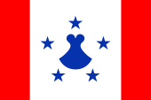
gibt es for lokale Zwecke eine inoffzielle Flagge. Sie zeigt drei senkrechte Streifen in Rot, Weiß und Rot (Verhältnis: 1:3:1). Im weißen Feld befindet sich ein blaues Emblem. Es besteht aus fünf blauen fünfzackigen Sternen und einem "Penu" in der Mitte. Die Sterne stehen für die fünf Gemeinden des Archipels. Das "Penu" steht für die gesamte Inselgruppe. Ein Penu ist ein traditioneller Stößel aus vulkanischem Gestein. Die Flagge erinnert mit ihren beiden roten Streifen daran, dass die Austral-Inseln im Jahre 1819 unter die Hoheit von Tahiti gekommen, und heute Teil von Französisch-Polynesien sind. Das Rot ist als Pantone 185c festgelegt, und das Blau als Pantone 286c. |
The Austral Islands – as a part of French Polynesia
– have officially no own flag. It must be hoisted the French tricolor or
additionally, the flag of French Polynesia. However, there exists for local
purposes an unofficial flag. It shows three vertical stripes in red, white and red (ratio: 1:3:1). In the white field is placed a blue emblem. It consists of five blue five-pointed stars and a "Penu" in the middle. The stars stand for the five municipalities of the archipelago. The "Penu" stands for the entire archipelago. A Penu is a traditional pestle made of volcanic rock. The flag - with its two red stripes remembers, that the Austral Islands came in 1819 under the sovereignty of Tahiti, and that they are today a part of French Polynesia. The colour red is defined as Pantone 185c, and the colour blue as Pantone 286c. |
| Quelle/Source: Wikipedia (D), Flags of the World | |
|
|
|
| Landkarten – Maps: |
Lage – Position: |
Landkarte von Französisch-Polynesien – Map of French Polynesia: |
Gliederungen von Französisch-Polynesien – Subdivisions of French Polynesia: |
| Zahlen und Fakten – Numbers and Facts: | |
|
|
|
|
|
|
|
|
|
|
|
|
|
|
|
|
| Quelle/Source: Wikipedia (D) | |
|
|
|
|
ca. 1200 n.Chr. · beginnende polynesische Besiedlung 1769 · der britische Seefahrer James Cook entdeckt die Inselgruppe und besucht Rurutu 1775 · der spanische Seefahrer Thomás de Gayangos entdeckt die Insel Raivavae 1777 · der britische Seefahrer James Cook entdeckt die Insel Tubuai 1789 · die Meuterer der Bounty leben drei Monate auf Tubuai 1791 · der britische Commander George Vancouver entdeckt die Insel Rapa Iti 1800 · der britische Seefahrer George Bass entdeckt die Insel Marotiri 1811 · der Holzhändler Samuel Pinder Henry entdeckt die Insel Rimatara 1824 · der US-amerikanische Walfänger George Washington Gardner entdeckt das unbewohnte Atoll Maria 1819 · König Pomaré II. von Tahiti wird gekrönt und besucht die Austral-Inseln – die Pomaré-Dynastie hatte mit britischer Unterstützung bereits die Gesellschaftsinseln und auch die Niedrigen Inseln unter ihre Kontrolle gebracht, die Austral-Inseln werden (außer Rurutu, Rimatara und Maria) einem tahitischen Statthalter unterstellt 1842 · Frankreich erklärt Tahiti zum französischen Protektorat 1874 · Frankreich erklärt die Tubuai zum französischen Protektorat 1876 · Frankreich erklärt die Raivavae zum französischen Protektorat 1880 · Frankreich annektiert Tahiti, mit Tahiti werden auch die Austral-Inseln (außer Rurutu, Rimatara und Maria) annektiert und werden französische Kolonie 27.03.1889 · Frankreich erklärt (nach Rücksprachen mit Großbritannien) das Königreich Rurutu zum französischen Protektorat 29.03.1889 · Frankreich erklärt (nach Rücksprachen mit Großbritannien) das Königreich Rimatara (inkl. Maria) zum französischen Protektorat 1900 · Frankreich annektiert Rurutu und Rimatara, die Inseln (inkl. Maria) werden französische Kolonie 1903 · Errichtung einer einheitlichen französischen Kolonialverwaltung für die Gesellschaftsinseln, Marquesas-Inseln, Tuamotuinseln, Gambier-Inseln und Austral-Inseln unter dem Namen "Französisch-Polynesien" |
|
|
|
ca. 1200 A.D. · beginning polynesian settlement 1769 · the British navigator James Cook discovers the islands and visits Rurutu 1775 · the Spanish seafarer Thomás de Gayangos discovers Raivavae Island 1777 · the British navigator James Cook discovers the Tubuai Island 1789 · the Bounty mutineers live for three months on Tubuai Island 1791 · the British Commander George Vancouver discovers Rapa Iti Island 1800 · the British navigator George Bass discovers Marotiri Island 1811 · the timber-merchant Samuel Pinder Henry discovers Rimatara Island 1824 · the US-american whaler George Washington Gardner discovers the uninhabited Maria Atoll 1819 · King Pomaré II. of Tahiti is crowned and visits the Austral Islands - the Pomaré dynasty had – with British support – already brought the Society Islands and the Low Islands under their control, the Austral Islands (except Rurutu, Rimatara and Maria) become subordinated under a Tahitian governor 1842 · France declares Tahiti to a French protectorate 1874 · France declares Tubuai Island to a French protectorate 1876 · France declares Raivavae Island to a French protectorate 1880 · France annexes Tahiti, with Tahiti are the Austral Islands become annexed to (except Rurutu, Rimatara and Maria) and become a French colony 27.03.1889 · France declares (after consultations with the United Kingdom) the Kingdom of Rurutu to French a protectorate 29.03.1889 · France declares (after consultations with the United Kingdom) the Kingdom of Rimatara (incl. Maria) to a French protectorate 1900 · France annexes Rurutu and Rimatara, the islands (incl. Maria) become a French colony 1903 · establishing of a unified French colonial administration for the Society Islands, Marquesas Islands, Tuamotu Islands, Gambier Islands and Austral Islands under the name "French Polynesia" |
| Quelle/Source: Wikipedia (D) |
|
|
| Der Name der Inseln als "Austral-Inseln" deutet deren geographische Lage als im Süden gelegene Inseln an. Sie sind tatsächlich die südlichsten Inseln Polynesiens. Jedoch wird der Name der Inselgruppe nur selten abgedruckt. Man konzentriert sich mehr auf die Tubuai-Inseln (die westlichen Austral-Inseln), die unbedeutenden Bass-Inseln (die östlichen Austral-Inseln) einfach ignorierend. | The name of the islands as "Austral Islands" indicates their geographical location as located in the southern islands. They are actually the southernmost islands of Polynesia. However, the name of the island group is rarely printed. more One concentrates simply ignoring the Tubuai Islands (Western Austral Islands), the insignificant Bass Islands (the eastern Austral Islands).| Quelle/Source:
Volker Preuß |
|
| ||