Kapkolonie |
|
|
|
| Übersicht – Contents: | |
Diese Seite ist Teil des Projektes
Kapkolonie |
|
|
|
| Übersicht – Contents: | |
Flaggen – Flags: |
|
 |
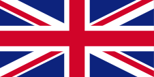
1814–1910, Union Flag → quasi Nationalflagge/national flag, Flagge von Großbritannien – flag of United Kingdom, Seitenverhältnis – ratio 1:2, Quelle/Source, nach/by: Flags of the World    |
 |
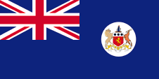
1875–1910, Flagge der Regierung (Staatsflagge) – flag of the government (state flag), Seitenverhältnis – ratio = 1:2, Quelle/Source, nach/by: Wikipedia (D), Flags of the World |
Bedeutung/Ursprung der Flagge – Meaning/Origin of the Flag: |
|
| Die Flagge der Kapkolonie war ein sogenannter "Blue Ensign", ein dunkelblaues Flaggentuch mit einer Flaggendarstellung – dem britischen Union Jack – in der Oberecke. Der Union Jack weist auf die Verbindungen zu Großbritannien hin. Die Flagge war zur Verwendung von Ämtern und Dienstellen gedacht und eigentlich auch nur zur See. Die Einwohner hatten weiterhin den britischen Union Jack zu verwenden. | The
flag of the Cape Colony was a so called "Blue Ensign", a dark blue
flag with a flag depiction – the British Union Jack – in the upper left
staff quadrant. The Union Jack points out to the connections to United Kingdom. The flag as intended for use by offices and departments and actually only at sea. Residents had furthermore to use the British Union Jack. |
Großbritannien hatte in Jahr 1864 ein Flaggensystem eingeführt, in dem:
Seit 1865 durften Schiffe von Kolonialregierungen einen Blue Ensign mit einem Badge (Abzeichen) im fliegenden Ende führen. Die jeweiligen Regierungen sollten entsprechene Bagdes zur Verfügung stellen. Handelsschiffe und seefahrende Privatpersonen aus Kolonien dürfen nur dann einen Red Ensign mit Badge führen, wenn von der britischen Admiralität eine entsprechende Erlaubnis für die Kolonie erteilt wurde. |
United Kingdom introduced a flag system in 1864 in which:
Since 1865 ships of colonial governments were permitted to fly the Blue Ensign with a badge in the flying end of the flag. The respective governments were asked to design appropriate badges. Merchant ships and seafaring persons from colonies were only permitted to use the Red Ensign with a badge, then also named Civil Ensign, if permission has been given to the respective colony by the British admiralty. |
| Ein solches Badge war oft eine auf einer Scheibe platzierte regionale landschaftliche Darstellung, zeigte oft Schiffe, historische Begebenheiten oder konnte auch nur eine Art Logo sein. Sehr oft zeigte ein Badge zusätzlich den Namen des Landes oder auch einen Wahlspruch. Einige Besitzungen hatten aber auch schon von Anfang an ein Wappen, bzw. erhielten über die Jahre eine eigenes Wappen und das Badge wurde abgeschafft. Um ein weitgehend einheitliches Erscheinungsbild im fliegenden Ende der Flaggen zu gewährleisten, wurden Wappen und auch andere Symbole auf einer weißen Scheibe in der Größe der früheren Badges dargestellt. Es gab hier aber auch Ausnahmen, denn einige Kolonien verwendeten diese weiße Scheibe nicht, und platzierten ihr Wappen oder auch nur das Wappenschild - manchmal auch vergrößert - direkt auf das Flaggentuch. Schon in den 40-er Jahre wurde dazu übergegangen die weiße Scheibe zu entfernen und das Wappen direkt zu platzieren oder vergrößert dazustellen. Dieser Umstellungsprozess erfolgte allmählich, nirgendwo gleichzeitig und vollständig. In einigen britischen Besitzungen sind bis heute Flaggen mit der weißen Scheibe in Gebrauch, in anderen nicht mehr und in einigen Gebieten gibt es beide Varianten nebeneinander. | Such a
badge was often a regional landscape representation placed on a disk, often
showing ships, historical events or even a kind of a logo. Very often, a
badge also showed the name of the country or a motto.
Some British possessions, however, already had a coat of arms from the beginning, or their badge was replaced by a coat of arms over the years. To ensure a uniform appearance in the flying end of the flags, coats of arms and other symbols were displayed on a white disk in the size of the earlier badges. There were also exceptions, because some colonies did not use the white disk and placed their escutcheon or even coat of arms directly on the bunting, sometimes enlarged. Already in the '40s they started to remove the white disk and placed the coat of arms directly or enlarged. This conversion process was done gradually, nowhere at the same time and completely. In some British possessions, flags with the white disc are still in use, in others no more and in some areas are both variants in use, next to each other. |
| Die Kapkolonie erhielt im Jahre 1875 ein eigenes Wappen, das auf einer weißen Scheibe im fliegenden Ende des "Blue Ensign" gezeigt wurde. | The Cape Colony became awarded an own coat of arms in the year 1875, which was shown within a wihite disk in the flying end of a "Blue Ensign". |
| Als Provinz Südafrikas hatte das Land bis 1994 keine eigene Flagge mehr. | As a province of South Africa the country had none own flag anymore until 1994. |
| Quelle/Source: Die Welt der Flaggen, Flags of the World | |
Wappen – Coat of Arms: |
|
 |
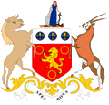
Wappen der Kapkolonie – coat of arms of the Cape Colony, Quelle/Source, nach/by: Flags of the World |
Bedeutung/Ursprung des Wappens – Meaning/Origin of the Coat of Arms: |
|
| Das Wappen der Kapkolonie zeigte ein rotes Schild mit einem goldenen Löwen, der von drei goldenen Ringen umgeben ist. Im Schildhaupt ein silbernes Feld mit drei blauen Scheiben die jeweils eine goldenen Lilie in sich tragen. Schildhalter waren ein Gnu und eine Antilope. Oberhalb des Schildes ein golden-roter Wulst und darauf eine Frauengestalt mit einem Anker, die an einem Felsen lehnt. Sie symbolisiert die Hoffnung. Unterhalb des Schildes ein silbernes Spruchband mit dem Motto der Kolonie: "Spes Bona" → "Gute Hoffnung". Das Motto und auch die Frauengestalt sind Anspielungen auf das Kap der Guten Hoffnung. | The coat
of arms of the Cape Colony showed a red shield with a golden lion which is
surrounded by three golden rings. In the head of the shield a silvery field
with three blue disks with each one golden lily inside. Shield-supporters were a gnu and a antelope. Above the shield a golden-red torus and on it a female figure with an anchor which is lean against a rock. It symbolizes hope. Below the shield a silvery banner with the motto of the colony: "Spes Bona" → "Good Hope". The motto and also the female figure are hints for the Cape of Good Hope. |
| Quelle/Source, nach/by: Flags of the World | |
Landkarte – Map: |
Landkarte des Landes – Map of the Country: |
|
Burenrepubliken und Britische
Kapkolonie heutige Grenzen in Rot Boer's Republics and Cape Colony today's borders in red |
|
Zahlen und Fakten – Numbers and Facts: |
|
|
|
|
|
|
|
|
|
|
|
| Quelle/Source, nach/by: Politische Gliederung der Erde, Brockhaus Konversationslexikon | |
Geschichte: |
|
Antike/Mittelalter · im heutigen Südafrika leben Khoisanide Völker (so
genannte Hottentotten oder Buschmänner) 1488 · der portugiesische Seefahrer Bartolomëu Diaz erreicht das Kap der Guten Hoffnung 1497 · der portugiesische Seefahrer Vasco da Gama umsegelt das Kap der Guten Hoffnung auf dem Weg nach Indien 15./16. Jahrhundert · Einwanderung schwarzer Bantu-Völker (Ndebele, Xhosa, Zulu, Sotho, Tswana, Swati, Venda, Tsonga ...) 1602 · die Niederländer nehmen das Land um das Kap der Guten Hoffnung in Besitz (Kapland), Besiedlung durch Buren (Bauern niederländischer und deutscher Abstammung, Eigenbezeichnung: Afrikaander) 1652 · Jan van Riebeeck gründet die Siedlung Kapstadt im Auftrag der Niederländisch-Ostindischen Kompanie 1806 · Großbritannien besetzt das Kapland 1814 · Großbritannien nimmt Kapland offiziell in Besitz, Gründung der Britischen Kapkolonie 1833 · Aufhebung der Sklaverei 1836–1885 · die Buren verlassen in langen Treks das Kapland in Richtung Osten und Nordosten und gründen mehrere Burenrepubliken (1838 Natal, 1854 Oranje-Freistaat, 1853 Transvaal, 1883 Stellaland, 1883 Goshen, 1884 Neue Republik ...), die britische Kolonialmacht verfolgt die Buren 1866 · Anschluss der Kolonie Kaffaria (im Süden des heutigen Südafrikas) an die Kapkolonie 1885 · Anschluss von Goshen und Stellaland (im Norden des heutigen Südafrikas) an die Kapkolonie 1887 · Anschluss von Zululand (im Osten des heutigen Südafrikas) an die Kapkolonie 1894 · Anschluss von Pondoland (im Süden des heutigen Südafrikas) an die Kapkolonie 1895 · Anschluss von Süd-Betschuanaland (im Norden des heutigen Südafrikas) an die Kapkolonie 1910 · Großbritannien schließt die Kolonien Oranje-Freistaat, Transvaal, Natal und Kapprovinz zur Südafrikanischen Union zusammen, Status eines britischen Dominions für Südafrika 27.04.1994 · neue Verfassung für Südafrika, Aufteilung der Kapprovinz |
History: |
|
Antiquity/Middle Ages · in the today’s South Africa live Khoisanide nations
(so named Hottentotts or Bushmen) 1488 · the Portugese seafarer Bartolomëu Diaz reaches the Cape of Good Hope 1497 · the Portugese seafarer Vasco da Gama sails around the Cape of Good Hope on the way to India 15th/16th century · immigration of black Bantu nations (Ndebele, Xhosa, Zulu, Sotho, Tswana, Swati, Venda, Tsonga ...) 1602 · the Netherlanders appropriate the land around the Cape of Good Hope (Kapland), settlement of Boers (farmer of Dutch and German descent, self-designation: Afrikaander) 1652 · Jan van Riebeeck founds the smallholding Kapstadt in mission of the Dutch East Indian Company 1806 · United Kingdom occupys Kapland 1814 · United Kingdom annexes Kapland officially, establishment of the British Cape Colony 1833 · abolition of slavery 1836–1885 · the Boers leave Kapland in long treks towards east and northeast and establish various Boer's republics (1838 Natal, 1854 Orange Free State, 1853 Transvaal, 1883 Stellaland, 1883 Goshen, 1884 New Republic ...), the British colonial power haunts the Boers 1866 · annexion of Kaffaria Colony (in the south of the today's South Africa) to the Cape Colony 1885 · annexion of Goshen and Stellaland (in the north of the today's South Africa) to the Cape Colony 1887 · annexion of Zululand (in the east of the today's South Africa) to the Cape Colony 1894 · annexion of Pondoland (in the south of the today's South Africa) to the Cape Colony 1895 · annexion of South Bechuanaland (in the north of the today's South Africa) to the Cape Colony 1910 · United Kingdom joins the colonies Orange Free State, Transvaal, Natal and Cape Province to the South African Union, status of a British dominion for South Africa 27.04.1994 · new constitution for South Africa, division of the Cape Province |
| Quelle/Source: Atlas zur Geschichte, Wikipedia (D), Discovery '97, Weltgeschichte |
Ursprung des Landesnamens – Origin of the Country's Name: |
|
| Der Name "Kapkolonie" bezieht sich auf die Lage des Landes am Kap der Guten Hoffnung. Die Niederländer nannten es "Kapland" und als Provinz Südafrikas wurde das Land "Kapprovinz" genannt. | The name "Cape Colony" has its roots in the position of the country at the Cape of Good Hope. The Netherlanders called it "Kapland" and as a province of South Africa the country was called "Cape Province". |
| Quelle/Source: Volker Preuß | |