Britisches Antarktis-Territorium |
|
|
|
| Übersicht – Contents: | |
Diese Seite ist Teil des Projektes
Britisches Antarktis-Territorium |
|
|
|
| Übersicht – Contents: | |
| Erklärung: | Explanation: |
| Das Britische Antarktis-Territorium ist international nur teilweise anerkannt. Der britische Besitz dieses Gebietes geht auf die Inbesitznahme der Süd-Shetland-Inseln im Jahre 1819, der Süd-Orkney-Inseln im Jahre 1821 und der Halbinsel Grahamland im Jahre 1832 zurück. Der bis heute bestehende britische Besitz der Falklandinseln, der Insel Südgeorgien und der Süd-Sandwich-Inseln (Südantillen) erlaubte Großbritannien die Beanspruchung eines Ganzen Sektors auf Antarktika im Jahre 1908, zwischen 20° und 80° W. Zwischen 1940 und 1942 begannen Chile und Argentinien Ansprüche auf das britische Gebiet zu erheben, die nicht nur wegen des britischen Besitzes der Südantillen haltlos waren und sind. Der Antarktisvertrag vom 01.12.1959 fror alle Ansprüche ein, und Besitz unterhalb 60° S wird auf Landkarten nicht mehr dargestellt. Die Britischen Besitzansprüche auf den Antarktischen Sektor sind durch Australien, Frankreich, Neuseeland und Norwegen anerkannt, jedoch nicht von den Vereinten Nationen, Argentinien, Chile, USA und Russland und vielen anderen Ländern. |
The British Antarctic
Territory is only partially recognised internationally. The British
possession of this territory dates back to the seizure of the South Shetland
Islands in 1819, the South Orkney Islands in 1821 and the Grahamland
Peninsula in 1832. The British possession of the Falkland Islands, the
island of South Georgia and the South Sandwich Islands (South Antilles),
which still exists today, allowed United Kingdom to claim an entire sector
of Antarctica in 1908, between 20° and 80° W. Between 1940 and 1942, Chile
and Argentina began to make claims to British territory, which were and are
unfounded, not only because of the British possession of the South Antilles.
The Antarctic Treaty of 1st of December in 1959 froze all claims, and
possession below 60° S is no longer shown on maps. The British claims to
ownership of the Antarctic sector are recognised by Australia, France, New
Zealand and Norway, but not by the United Nations, Argentina, Chile, the
USA, Russia and many other countries. |
| Quelle/Source: Volker Preuss | |
|
|
|
Flaggen – Flags: |
|
 |
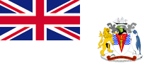
Nationalflagge – national flag, Seitenverhältnis – ratio = 1:2, Quelle/Source, nach/by: Flags of all Nations |
 |
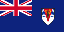
Flagge der Regierung – governmental flag, Seitenverhältnis – ratio = 1:2, Quelle/Source, nach/by: Flags of all Nations |
 |
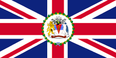
Flagge des Kommissars für das B.A.T. – flag of the Commissioner of the B.A.T., Seitenverhältnis – ratio = 1:2, Quelle/Source, nach/by: Flags of all Nations |
|
|
|
Bedeutung/Ursprung der Flagge – Meaning/Origin of the Flag: |
|
|
Das heutige Britische
Antarktis-Territorium (BAT) wurde 1908 durch Großbritannien in Besitz
genommen. Im Prinzip müssten von daher, ab diesem Zeitpunkt, der einzelne
Bürger und auch die Behörden ihren Status als Bürger oder Organe der
britischen Nation, verkörpert im United Kingdom, durch die Verwendung des
Union Jack, dann "Union Flag" genannt, repräsentierten. Damit wäre an Land
die Unionsflagge die National- und Staatsflagge. Entgegen dieser sonst
üblichen Verfahrensweise ist die Nationalflagge des BAT ein sogenannter
White Ensign", ein weißes Flaggentuch mit einer Flaggendarstellung – dem
britischen Union Jack – in der Oberecke, der auf die Verbindungen zu
Großbritannien hinweist. Vermutlich gibt es diese außergewöhnliche
Festlegung um die Bestimmungen des Der Antarktisvertrags von 1959 nicht zu
unterlaufen, denn der Antarktisvertrag fror alle territorialen Ansprüche
ein, und Besitz unterhalb 60° S soll z.B. auf Landkarten nicht mehr
dargestellt werden. Großbritannien hatte in Jahr 1864 ein Flaggensystem eingeführt, in dem: • Kriegsschiffe einen sogenannten "White Ensign" (Marineflagge), eine weiße Flagge oft mit durchgehendem roten Georgskreuz und mit dem Union Jack in der Oberecke, • Handelsschiffe einen "Red Ensign" (auch "Civil Ensign" → Bürgerflagge genannt, die eigentl. Handelsflagge), eine rote Flagge mit dem Union Jack in der Oberecke, und • Dienstschiffe einen "Blue Ensign" (Regierungsflagge → die eigentliche Staatsflagge), eine blaue Flagge mit dem Union Jack in der Oberecke führten. Seit 1865 durften Schiffe von Kolonialregierungen einen Blue Ensign mit einem Badge (Abzeichen) im fliegenden Ende führen. Die jeweiligen Regierungen sollten die entsprechenden Bagdes zur Verfügung stellen. Das BAT führt in seinen Flaggen das Wappen bzw. den Schild des 1952 verliehenen Wappens. Es zeigt antarktische Motive, Eis, spärliche Vegetation, ein Schiff und als Schildhalter einen Pinguin und den britischen Löwen. Der Wappenspruch lautet "Forschung und Entdeckung". Die Flagge der Regierung zur See, der "Blue Ensign", wird von Schiffen des Nationalen Umwelt- und Forschungsrates gezeigt, wenn sie zu Inspektionsfahrten in Britisch Antarktika weilen. Die Flagge des Kommissars für das BAT ist ein Standard-Design, älterer Machart, für alle Gouverneure, Leutnant-Gouverneure, Kommissare, Hohen Kommissare und anderer Beamter, die ein entsprechendes Amt ausüben, vorausgesetzt, dass kein neuerer Entwurf verwendet wird. Innerhalb des Kranzes befindet sich immer das entsprechende Badge oder Wappen. |
Today's British Antarctic
Territory (BAT) was taken possession of by United Kingdom in 1908. In
principle, from this point onwards, individuals, citizens and also the
authorities would have to represent their status as citizens or organs of
the British nation, embodied in the United Kingdom, by using of the Union
Jack, then called the "Union Flag". This would make the Union Flag the
national and state flag on land. Contrary to this usual procedure, the national flag of the BAT is a so-called "White Ensign", a white bunting with a flag representation – the British Union Jack – in the upper corner, which indicates the connections to United Kingdom. Presumably, this unusual specification exists in order not to undermine the provisions of the Antarctic Treaty of 1959, as the Antarctic Treaty froze all territorial claims, and possessions below 60° S should no longer be shown on maps, for example. United Kingdom introduced a flag system in 1864 in which: • war ships fly the "White Ensign" (naval flag), a white flag often with an uninterrupted red St. George's-Cross and with the Union Jack in the upper staff quadrant of the flag, • merchant ships fly a "Red Ensign" (also named "Civil Ensign" → civil flag, the real merchant flag), a red flag with the Union Jack in the upper staff quadrant of the flag, and • governmental ships fly the "Blue Ensign" (flag for the use by the gouvernment → the actual state flag), a blue flag with the Union Jack in the upper staff quadrant of the flag. From 1865, the ships of the colonial governments were allowed to use a Blue Ensign with a badge at the flying end. The respective governments were to provide appropriate badges. The BAT uses the coat of arms or shield of the coat of arms – awarded in 1952 – in its flags. It shows Antarctic motifs, ice, sparse vegetation, a ship and, as shield holders, a penguin and the British lion. The coat of arms motto is "Research and Discovery". The government flag at sea, the "Blue Ensign", is flown by ships of the National Environment and Research Council when they visit British Antarctica on inspection cruises. The flag of the Commissioner of the BAT is a standard flag, of older design, for all Governors, Lieutenant-Governors, Commissioners, High Commissioners and other officials holding a corresponding office, provided that no newer design is used. Within the wreath is always placed the appropriate badge or coat of arms. |
| Quelle/Source: Die Welt der Flaggen, Flaggen und Wappen, Flaggen Wappen Hymnen | |
|
|
|
Wappen – Coat of Arms: |
|
 |
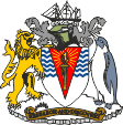
Wappen Britisches Antarktis-Territorium – coat of arms of the British Antarctic Territory, Quelle/Source: Corel Draw 4 |
|
|
|
Bedeutung/Ursprung des Wappens – Meaning/Origin of the Coat of Arms: |
|
| Das Wappenschild ist silbern (weiß, es steht für das ewige Eis) und zeigt im oberen Teil blaue Wellenlinien (die antarktischen Gewässer) und einen roten Keil, der mit einer strahlenden, goldenen Fackel belegt ist (Forschung, Entdeckung). Das Wappen zeigt als Podest antarktische Motive wie Eis und spärliche Vegetation. Auf dem Podest stehen als Schildhalter ein Pinguin und der britische Löwe. Das Wappen ist von einem Helm und einer grauen Helmdecke mit einer weißen Wulst bekrönt, darauf, als Helmkleinod, ein Segelschiff. Der Wappenspruch lautet "Research and Discovery" → "Forschung und Entdeckung". |
The shield of the coat of
arms is silver (white, it stands for the eternal ice) and shows in the upper
part blue wavy lines (the Antarctic waters) and a red wedge, which is
covered with a shining, golden torch (research, discovery). The coat of arms shows Antarctic motifs such as ice and sparse vegetation as a pedestal. A penguin and the British lion stand on the pedestal as supporters (shield holders). The coat of arms is crowned by a helmet and a grey mantling with a white torse, and on it, as crest, a sailing ship. The Motto is: "Research and Discovery". |
| Quelle/Source: Corel Draw 4, Volker Preuss | |
|
|
|
| Landkarte – Map: |
|
|
|
Zahlen und Fakten – Numbers and Facts: |
|
|
|
|
|
|
|
|
|
|
|
|
|
|
|
|
Geschichte: |
| 1819
· Inbesitznahme der Süd-Shetland-Inseln durch Großbritannien 1821 · Inbesitznahme der Süd-Orkney-Inseln durch Großbritannien 1832 · Inbesitznahme der Halbinsel Grahamland durch Großbritannien 1903–1904 · erste britische Forschungsstation auf den Süd-Orkney-Inseln 1908 · Großbritannien erhebt Ansprüche auf den Antarktischen Sektor südlich 50° S und zwischen 20° W und 80° W, die Süd-Shetland-Inseln und die Süd-Orkney-Inseln werden Dependenzen der britischen Falklandinseln 1940 · die Süd-Shetland-Inseln werden von Chile beansprucht 1942 · die Süd-Shetland-Inseln werden von Argentinien beansprucht 1943–1945 · Britische Forschungsmission, Errichtung wissenschaftlicher Stationen 01.12.1959 · Antarktisvertrag zwischen Argentinien, Australien, Belgien, Chile, Frankreich, Japan, Neuseeland, Südafrika, Sowjetunion, Großbritannien und USA 03.03.1962 · Abtrennung der Süd-Shetland-Inseln und die Süd-Orkney-Inseln von den Falklandinseln, Schaffung des Britischen Antarktis-Territoriums mit den Süd-Shetland-Inseln, den Süd-Orkney-Inseln und Grahamland |
|
|
History: |
| 1819
· appropriation of the South Shetland Islands by the United Kingdom 1821 · appropriation of the South Orkney Islands by the United Kingdom 1832 · appropriation of the peninsula of Graham Land by the United Kingdom 1903–1904 · first British research station on the South Orkney Islands 1908 · the United Kingdom claims the Antarctic sector south of 50° S and between 20° W and 80° W, the South Shetland Islands and the South Orkney Islands become Dependencies of the British Falkland Islands 1940 · the South Shetland Islands are claimed by Chile 1942 · the South Shetland Islands are claimed by Argentina 1943–1945 · British research mission, establishment of scientific stations 1st of December 1959 · Antarctic Treaty between Argentina, Australia, Belgium, Chile, France, Japan, New Zealand, South Africa, Soviet Union, Britain and USA 3rd of March 1962 · separation of the South Shetland Islands and the South Orkney Islands from the Falkland Islands, creation of the British Antarctic Territory with South Shetland Islands, South Orkney Islands and Graham Land |
| Quelle/Source: World Statesmen, Wikipedia (D) |
|
|
Ursprung des Landesnamens – Origin of the Country's Name: |
|
| Die Süd-Shetland-Inseln und die Süd-Orkney-Inseln erhielten ihren Namen als Pendant zu den Shetland-Inseln und Orkney-Inseln im Norden, an der Küste Großbritanniens. Grahamland wurde 1832 entdeckt und ist nach dem damaligen Admiral der Royal Navy benannt: James Robert George Graham. | The South Shetland Islands and the South Orkney Islands were named as a counterpart to the Shetland Islands and Orkney Islands in the north, on the coast of Britain. Graham Land was discovered in 1832 and is named after the Admiral of the Royal Navy of those years: James Robert George Graham. |
| Quelle/Source: Wikipedia (D), Volker Preuss | |
|
|
|