Pinang |
|
|
|
| Übersicht – Contents: | |
Diese Seite ist Teil des Projektes
Pinang |
|
|
|
| Übersicht – Contents: | |
Flaggen – Flags: |
|
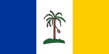 |
Flagge von Pinang – flag of Penang, Seitenverhältnis – ratio = 1:2, Quelle/Source: Flaggen Enzyklopädie |
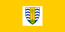 |
Flagge des Gouverneurs von Pinang – flag of the Governor of Penang, Seitenverhältnis – ratio = 1:2, Quelle/Source: www.penang.gov.my/en/ |
historische Flaggen – historical Flags: |
|
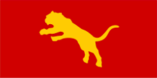 |
1821–1867, Flagge von Kedah – flag of Kedah, Quelle/Source, nach/by: Die Welt im bunten Flaggenbild, Wikipedia (EN) |
 |
1867–1949, Union Flag → quasi Nationalflagge, |
 |
1867–1949, |
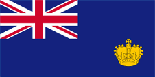 |
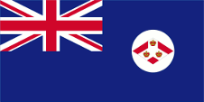
1868–1877, Pinang ist Teil der Straits Settlements – Penang is part of the Straits Settlements, Flagge der Regierung (Staatsflagge) – flag of the government (state flag), Seitenverhältnis – ratio = 1:2, Quelle/Source nach/by: Flags of the World |
 |
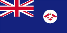
1879–1904, Pinang ist Teil der Straits Settlements – Penang is part of the Straits Settlements, Flagge der Regierung (Staatsflagge) – flag of the government (state flag), Seitenverhältnis – ratio = 1:2, Quelle/Source nach/by: Flags of the World |
 |
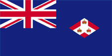
1904–1925, Pinang ist Teil der Straits Settlements – Penang is part of the Straits Settlements, Flagge der Regierung (Staatsflagge) – flag of the government (state flag), Seitenverhältnis – ratio = 1:2, Quelle/Source nach/by: Flags of the World |
 |
1925–1941, Pinang ist Teil der Straits Settlements – Penang is part of the Straits Settlements, Flagge der Regierung (Staatsflagge) – flag of the government (state flag), Seitenverhältnis – ratio = 1:2, Quelle/Source nach/by: Flags of the World |
 |
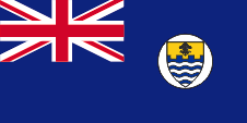
1941–1945, Pinang ist von Japan besetzt – Penang is occupied by Japan, Seitenverhältnis – ratio = 7:10, Quelle/Source, nach/by: Wikipedia (EN)  |
 |
1946–1949, Flagge der Regierung (Staatsflagge) – flag of the government (state flag), Seitenverhältnis – ratio = 1:2, Quelle/Source nach/by: Wikipedia (EN) |
Bedeutung/Ursprung der Flagge – Meaning/Origin of the Flag: |
|
| Die Flagge von Pinang wurde 1949 eingeführt und zeigt drei senkrechte Streifen in Blau, Weiß und Gelb. In der Mitte des weißen Streifens befindet sich ein Pinang-Baum, eine Betelnusspalme, auf den der Namen des Staates zurückgeht. Das Blau steht für das Meer, das Weiß für die Würde des Landes, das Gelb für Wohlstand. | The flag of Pinang was introduced in 1949 and shows three vertical strips in blue, white and yellow. In the middle of the white stripe is placed a Pinang tree, a Betel nut palm tree (Areca), to which the name of the state goes back. The blue stands for the sea, the white for the dignity of the country and the yellow for prosperity. |
| In den Jahren vor 1949 war Pinang auch von seinen Flaggen her in das britische koloniale System eingebunden. Zunächst als Teil der Straits Settlements, nach deren Auflösung ab 1946 als eigenständige Kolonie. | In the years before 1949, Pinang was with its flags also involved in the British colonial system. Initially as part of the Straits Settlements, after their dissolution in 1946 as a separate colony. |
Großbritannien hatte
in Jahr 1864 ein Flaggensystem eingeführt, in dem:
Seit 1865 durften Schiffe von Kolonialregierungen einen Blue Ensign mit einem Badge (Abzeichen) im fliegenden Ende führen. Das Badge der Straits Settlements zeigte drei britische Kronen. |
Great Britain
introduced a flag system in 1864 in which:
Since 1865 ships of colonial governments were permitted to fly the Blue Ensign with a badge in the flying end of the flag. The badge of the Straits Settlements showed three British crowns. |
| An Land repräsentierten der einzelne Bürger und auch die Behörden ihren Status als Bürger oder Organe der britischen Nation, verkörpert im United Kingdom, durch die Verwendung des Union Jack, dann „Union Flag“ genannt. Zur See war somit für den britischen Bürger die britische Handelsflagge, der Red Ensign (Rote Flagge) vorgesehen. In einigen wenigen Fällen wurde den Bürgern einer Kolonie durch die Admiralität erlaubt, auf See einen Red Ensign mit dem Badge der Kolonie zu verwenden. |
On land, the individual
citizen and also the authorities represented their status as citizens or
organs of the British nation, embodied in the United Kingdom, through the
use of the Union Jack, then called the "Union Flag". At sea, the British citizen was thus provided with the British merchant flag, the Red Ensign. In a few cases, the citizens of a colony were allowed by the Admiralty to use their own Red Ensign with the colony's badge at sea. |
| Pinang erhielt im Jahre 1946 ein eigenes Badge. Es war ein geteilter Wappenschild, unten blaue und weiße Wellen, mit Zinnenschnitt vom goldenen Schildhaupt getrennt, das in der Mitte ein Bündel von blauen Prinz-von-Wales-Federn zeigte. Dieses Wappen geht auf das Wappen der Stadt Georgetown zurück. Die Prinz-von-Wales-Federn erinnern daran, dass die Insel Pinang 1786 als Prinz-von-Wales-Insel in britischen Besitz kam. | Pinang got his own badge in the year 1946. It was a splited shield, with blue and white waves underneath, separated by a pinnacle-line from the golden shield-head, which showed a bundle of blue Prince of Wales's feathers in the middle. This coat of arms goes back to the coat of arms of the city of Georgetown. The Prince of Wales's feathers remember, that Penang Island became in 1786 a British possession as Prince of Wales Island. |
| Quelle/Source: Flaggen Enzyklopädie, Die Welt der Flaggen, Flags of the World | |
Wappen – Coat of Arms: |
|
 |
seit/since 1988, Wappen von Pinang – coat of arms of Penang, Quelle/Source, nach by: www.penang.gov.my, Wikipedia (EN) |
 |
seit/since 1957, Wappen des Gouverneurs von Pinang – coat of arms of the Governor of Penang, Quelle/Source, nach by: www.penang.gov.my, Wikipedia (EN) |
 |
1950–1988, Wappen von Pinang – coat of arms of Penang, Quelle/Source, nach by: www.penang.gov.my, Wikipedia (EN) |
 |
1946–1950, Wappen von Pinang – coat of arms of Penang, Quelle/Source, nach by: www.penang.gov.my, Wikipedia (EN) |
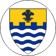 |
1946–1949, Badge von Pinang – badge of Penang, Quelle/Source, nach by: www.penang.gov.my, Wikipedia (EN) |
Bedeutung/Ursprung des Wappens – Meaning/Origin of the Coat of Arms: |
|
| Das heutige Wappen von Pinang wurde 1988 eingeführt. Dazu wurde das bisherige Wappen im Schildhaupt abgeändert, die Zinnen und die Federn entfernt, und statt dessen die Pinang-Brücke ins Schildhaupt aufgenommen. Ebenso wurde das silberne Spruchband mit dem Motto "BERSATU DAN SETIA" ("vereint und treu") golden eingefärbt. | The today's coat of arms of Pinang was introduced in 1988. In this way the previous coat of arms was modified in the head of the shield, the pinnacles and feathers became removed, and instead the Pinang bridge was added to the head of the shield. The silvery banner with the motto "BERSATU DAN SETIA" ("United and Loyal") became golden colored. |
| Quelle/Source: Wikipedia (EN) | |
Landkarte – Map: |
|
|
| Die Bundesstaaten Malaysias – the Federal States of Malaysia: |
| interaktive Landkarte – interactive Map |
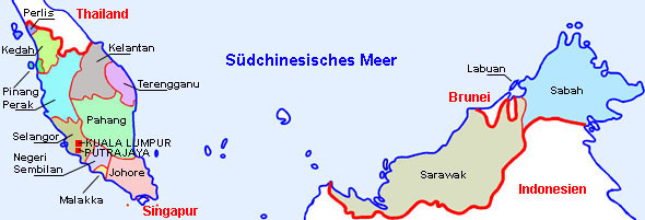 Landkarte/Map: Volker Preuß nach/to Malaysia? → hier klicken – click here |
Zahlen und Fakten – Numbers and Facts: |
|
|
|
|
|
|
|
|
|
|
|
|
|
|
|
|
|
|
|
|
|
|
Geschichte: |
|
7.–11.Jhd. · zum Reich Shrividjaja 11. Jhd. · erste Erwähnung eines Staates Kadaram (Kedah) in der Region, zu dem das heutige Pinang gehört 12. Jhd. · Islamisierung 14.–15. Jhd. · zum Reich Siam 15. Jhd. · Eroberung durch Malakka 17. Jhd. · Angriffe durch Portugiesen, Kedah kommt vorübergehend unter Kontrolle des Sultanats Aceh 1786 · der Sultan von Kedah ruft gegen Siam (Thailand) die Britische Ostindienkompanie zu Hilfe, Francis Light besetzt die Insel Pinang und baut sie zu einem Stützpunkt aus 1800 · die Britische Ostindienkompanie erwirbt das Festland gegenüber von Pinang (Provinz Wellesley) 14.08.1826 · Singapur wird mit Pinang und Malakka zur Kolonie "Straits Settlements" unter der Oberhoheit der Britischen Ostindienkompanie zusammengeschlossen, Verwaltungssitz ist Gerorgetown auf Pinang 1832 · der Verwaltungssitz der Straits Settlements wird von Pinang nach Singapur verlegt 1858 · die Verwaltung der Straits Settlements geht auf Britisch-Indien über 01.04.1867 · die Straits Settlements werden britische Kronkolonie 1941 · japanische Eroberung 1945 · Abzug der Japaner 01.04.1946 · Bildung der Malaiischen Union durch Zusammenschluss der Malaiischen Sultanate (Britische Protektorate) und der Straits Settlements (Britische Kronkolonien), jedoch ohne Singapur. Pinang (einschließlich Wellesley) wird somit als britische Kolonie Teil der Union 1948 · Reorganisation der Malaiischen Union, Bildung der Malaiischen Föderation unter einem britischen Hochkommissar 31.08.1957 · Unabhängigkeit und Proklamation des Königreiches Malaiische Föderation 16.09.1963 · Proklamation des Königreiches Malaysia durch Zusammenschluss der Malaiischen Föderation (Malaya) mit den ehemaligen britischen Kolonien Sarawak, Sabah (Nordborneo) und Singapur. Brunei lehnte den Beitritt ab und verblieb bei Großbritannien 09.08.1965 · Singapur verlässt die Föderation von Malaysia |
History: |
|
7th–11th cent. · to the Shrividjaja Empire 11th cent. · first mention of a state of Kadaram (Kedah) in the region, to which today's Penang belongs 12th cent. · Islamisation 14th-15th cent. · to the empire of Siam 15th cent. · Conquest by Malacca 17th cent. · Portuguese attacks, Kedah temporarily comes under the control of the Sultanate of Aceh 1786 · the Sultan of Kedah calls for the British East India Company against Siam (Thailand), Francis Light occupies Penang Island and develops it to a base 1800 · the British East India Company acquires the mainland across from Pinang Island (Wellesley Province) 14th of August 1826 · Singapore becomes joined with Penang and Malacca to the colony of the "Straits Settlements" under the supremacy of the British East India Company, seat of government is Gerorge Town on Pinang Island 1832 · the seat of government of the Straits Settlements becomes transfered from Penang to Singapore 1858 · the administration of the Straits Settlements becomes handed over to British India 1st of April 1867 · the Straits Settlements become a British crown colony 1941 · Japanese conquest 1945 · withdrawal of the Japanese 1st of April 1946 · formation of the Malay Union by confederation of the Malaysian Sultanates (British protectorates) and the Straits Settlements (British crown colonies), but without Singapore. Penang (inclusive Wellesley) as a British colony becomes in this way a part of the union 1948 · re-organization of the Malaysian Union, creation of the Malaysian Federation under a British High Commissioner 31st of August 1957 · independence and proclamation of the Kingdom of Malaysian Federation 16th of September 1963 · proclamation of the Kingdom of Malaysia by confederation of the Malaysian Federation (Malaya) with the former British colonies Sarawak, Sabah (North Borneo) and Singapore. Brunei rejects the joining and remains at Great Britain 9th of August 1965 · Singapore leaves the Federation of Malaysia |
| Quelle/Source: Atlas zur Geschichte, Wikipedia (D), Discovery '97, Weltgeschichte |
Ursprung des Landesnamens – Origin of the Country's Name: |
|
| Der Name Pinang geht auf den modernen malaiischen Namen "Pulau Pinang" zurück, was mit "Arekanuss-Insel" oder "Betelnuss-Insel" zu übersetzen wäre. Ursprünglich wurde die Insel in dieser Region "Pulau Ka-Satu" genannt, die "Erste Insel", weil sie die erste große auffällige Insel auf dem Seeweg zwischen Lingga und Kedah war. Auch die Siamesen nannten die Insel so, jedoch in ihrer Sprache "Koh Maak". Der eigentliche Wurzel des Namens Pinang geht auf deren chinesischen Namen des 15. Jahrhunderts zurück: "Binlang Yu" zurück ("Arekanuss-Insel"). Der portugiesische Gelehrte Emanuel Godinho de Eredia mischte dann im 16. Jahrhundert Chinesisch und Malaiisch zu "Pulo Pinaom", woraus viel Jahre später "Pulau Pinang" wurde. Andere, poetische Namen, die dem Land gerne gegeben werden sind: "Perle des Orients" und "Insel der Perlen" ("Pulau Mutiara"). |
The name Pinang derives from the modern Malay name "Pulau Pinang", which
would be translated as "Areca Nut Island" or "Betel Nut Island". Originally, the island in this
region was called "Pulau Ka-Satu", the "First Island", because it was the
first large conspicuous island on the sea route between Lingga and Kedah.
The Siamese also called the island this, but in their language "Koh Maak".
The actual root of the name Pinang goes back to their 15th century
Chinese name: "Binlang Yu" ("Arekanuss Island"). The Portuguese scholar
Emanuel Godinho de Eredia then mixed Chinese and Malay to "Pulo Pinaom" in
the 16th century, which became "Pulau Pinang" many years later. Other,
poetic names that are readily given to the country are: "Pearl of the
Orient" and "Island of Pearls" ("Pulau Mutiara"). |
| Quelle/Source: Wikipedia (EN) | |