|
|
| Übersicht – Contents: | |
|
|
Diese Seite ist Teil des Projektes
|
|
| Übersicht – Contents: | |
|
|
| Landkarte – Map: |
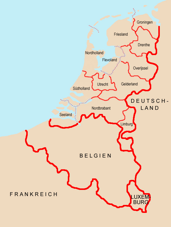 |
| Landkarte/Map: Volker Preuß |
|
Friesland (friesisch: Fryslân) |
|
|
Fläche/area: 3.353 km² Einwohner/inh.: 644.000 (2008) Hauptstadt/capital: Leeuwarden |
|
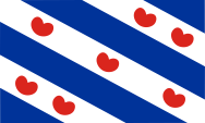 |
Flagge der Provinz Friesland – flag of the Province of Friesland |
| Ganz Friesland (Westfriesland, Groningen und Ostfriesland) verlieb lange Zeit außerhalb der Feudalordnung, und die einzelnen Gemeinden waren direkt dem Deutschen Kaiser unterstelllt. Das blieb auch so, als Westfriesland 1524 und Groningen 1536 Habsburgischer Besitz wurden. Friesland gehörte ab 1579 zur "Utrechter Union" und ab 1581 zur "Republik der Vereinigten Niederlande". Die Flagge der Provinz Friesland wurde 1957 angenommen und geht auf ein Wappen des 15. Jahrhunderts zurück. Die weißen und blauen Streifen und die Seerosenblätter repräsentieren die Gemeinden der Provinz. |
All of Friesland (West Friesland, Groningen and East Friesland) existed in a
long time outside the feudal system and the individual communities had been
subordinated directly to the German emperor. This stayed like that, as West
Friesland in 1524 an Groningen in 1536 became an Habsburg possession. Friesland belonged from 1579 to the "Union of Utrecht" and from 1581 to the "Republic of the United Netherlands". The flag of the Province of Friesland was adopted in 1957 and goes back to a coat of arms of the 15th century. The white and blue stripes and the lily pads represent the municipalities of the province. |
| Quelle/Source: Wikipedia (D), Flaggen Enzyklopädie, Atlas zur Geschichte, Discovery '97 | |
| Groningen | |
|
Fläche/area: 2.607 km² Einwohner/inh.: 572.000 (2008) Hauptstadt/capital: Groningen |
|
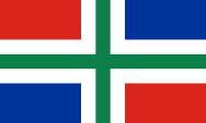 |
Flagge der Provinz Groningen – flag of the Province of Groningen |
|
Groningen gehörte zunächst zu Friesland, wurde jedoch 1536 Habsburgischer
Besitz, gehörte ab 1579 zur "Utrechter Union" und ab 1581 zur "Republik der
Vereinigten Niederlande". Die Flagge der Provinz Groningen wurde 1950
angenommen und kombiniert die Farben der Stadt Groningen (Gründ und Weiß)
mit den Farben von Ommeland (Rot, Weiß und Blau). |
Groningen initially belonged to Frisia, however, it became in 1536 an Habsburg possession belonged from 1579 to the "Union of Utrecht" and from 1581 to the "Republic of the United Netherlands". The flag of the Province of Groningen was adopted in 1950, combining the colors of the City of Groningen (green and white) with the colors of Ommeland (red, white and blue). |
| Quelle/Source: Wikipedia (D), Flaggen Enzyklopädie, Atlas zur Geschichte, Discovery '97 | |
| Drenthe | |
|
Fläche/area: 2.685 km² Einwohner/inh.: 489.000 (2008) Hauptstadt/capital: Assen |
|
 |
Flagge der Provinz Drenthe – flag of the Province of Drenthe |
| Drenthe gehörte zunächst bis 1528 zum Bistum Utrecht, wurde jedoch 1536 als Grafschaft Drenthe Habsburgischer Besitz, gehörte ab 1579 zur "Utrechter Union" und ab 1581 zur "Republik der Vereinigten Niederlande". Die Flagge der Provinz Drenthe wurde 1950 angenommen. Die Farben Rot und Weiß gehen auf das Bistum Utrecht zurück, zu dem diese Provinz früher gehörte. Die stilisierte schwarze Burg steht für die Burg Coevorden, auf der im Jahre 1227 ein Aufstand gegen den Bischof von Utrecht begann. Die sechs Sterne repräsentieren die historischen sechs Gerichtsplätze der Region. |
Drenthe belonged initially to 1528 to the Diocese of Utrecht, became in 1536
an Habsburg possession as a county, belonged from 1579 to the "Union of
Utrecht" and from 1581 to the "Republic of the United Netherlands". The flag of the Province of Drenthe was adopted in 1950. The colors red and white go back to the Diocese of Utrecht, to which this province formerly belonged. The stylized black castle is Coevorden Castle, where in 1227 started a revolt against the Bishop of Utrecht. The six stars represent the historic six court sites in the region. |
| Quelle/Source: Wikipedia (D), Flaggen Enzyklopädie, Atlas zur Geschichte, Discovery '97 | |
| Gelderland | |
|
Fläche/area: 5.011 km² Einwohner/inh.: 1.988.000 (2008) Hauptstadt/capital: Arnheim |
|
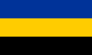 |
Flagge der Provinz Gelderland – flag of the Province of Gelderland |
| Gelderland war ab 1339 Teil des Herzogtums Geldern, welches 1383 dem Herzog von Jülich übertragen wurde. Es wurde 1543 Habsburgischer Besitz, gehörte ab 1579 zur "Utrechter Union" und ab 1581 zur "Republik der Vereinigten Niederlande". Die Flagge der Provinz Gelderland wurde 1953 angenommen. Ihre Farben gehen auf die Wappen des Herzogtums Geldern (goldener Löwe auf Blau) und des Herzogtums Jülich (schwarzer Löwe auf Gold) zurück, deren Farben in dieser Flagge kombiniert werden. |
Gelderland was from 1339 a part of the Duchy of Geldern, which in 1383 was
transferred to the Duke of Julich. It became in 1543 an Habsburg possession,
belonged from 1579 to the "Union of Utrecht" and from 1581 to the "Republic
of the United Netherlands". The flag of the Province of
Gelderland was adopted in 1953. Its colors go back to the crest of the Duchy
of Geldern (golden lion on blue) and the Duchy of Julich (black lion on
gold). Their colors had been combined in this flag. |
| Quelle/Source: Wikipedia (D), Flaggen Enzyklopädie, Atlas zur Geschichte, Discovery '97 | |
| Overijssel | |
|
Fläche/area: 3.926 km² Einwohner/inh.: 1.123.000 (2008) Hauptstadt/capital: Zwolle |
|
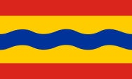 |
Flagge der Provinz Overijssel – flag of the Province of Overijssel |
| Overijssel gehörte zum Bistum Utrecht, bis es 1528 Habsburgischer Besitz wurde. Es gehörte ab 1579 zur "Utrechter Union" und ab 1581 zur "Republik der Vereinigten Niederlande". Die Flagge der Provinz Overijssel wurde 1948 angenommen. Ihre Farben gehen auf das Wappen von Overijssel zurück. Es ist das Wappen Hollands, ein roter Löwe auf Gold, mit einem gewellten, blauen, waagerechten Balken. In der Flagge soll die Wellenlinie auch den Fluss Ijssel darstellen. |
Overijssel belonged to the Diocese of Utrecht until 1528, when it became an
Habsburg possession. It belonged from 1579 to the "Union of Utrecht" and
from 1581 to the "Republic of the United Netherlands". The flag of the Province of Overijssel was adopted in 1948. Its colors go back to the arms of Overijssel. It is the arms of Holland, a red lion on gold, with a corrugated, blue, horizontal bar. In the flag the wave line should represent the river Ijssel. |
| Quelle/Source: Wikipedia (D), Flaggen Enzyklopädie, Atlas zur Geschichte, Discovery '97 | |
|
Flevoland (auch Ostpolder, nied.: Oost-Polder) |
|
|
Fläche/area: 1.422 km² Einwohner/inh.: 381.000 (2008) Hauptstadt/capital: Lelystad |
|
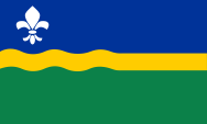 |
Flagge der Provinz Flevoland – flag of the Province of Flevoland |
| Flevoland wurde durch Trockenlegung des Ijsselmeeres zwischen 1957 und 1968 geschaffen. Das soll auch in der Gestaltung der 1986 eingeführten Flagge zum Ausdruck gebracht werden, in dem die gelbe Wellenlinie in der Mitte in einer geraden Linie ausläuft. Blau steht für das Wasser, Grün für das Land und Gelb für den Raps, der als erstes auf den trockenen Flächen angebaut worden ist. Die Lilie soll an den Namen von Cornelis Lely erinnern, der die Landgewinnung gegen Ende des 19. Jahrhunderts ingenieurtechnisch geplant hat. |
Flevoland was created by reclamation of the Ijssel Sea between 1957 and
1968. This should be expressed in the design of the in 1986 introduced flag,
through the expiry of the yellow wavy line in the middle into a straight
line. Blue
stands for water, green for the land and yellow for the rape, which was
first cultivated on the dry land. The lily should remember the name of
Cornelis Lely, who has planned the land reclamation in the late 19th century
has planned. |
| Quelle/Source: Wikipedia (D), Flaggen Enzyklopädie, Discovery '97 | |
| Utrecht | |
|
Fläche/area: 1.396 km² Einwohner/inh.: 1.206.000 (2008) Hauptstadt/capital: Utrecht |
|
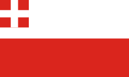 |
Flagge der Provinz Utrecht – flag of the Province of Utrecht |
|
Das Bistum Utrecht wurde 695 gegründet, bis es 1528 Habsburgischer Besitz
wurde. Es gehörte ab 1579 zur "Utrechter Union" und ab 1581 zur "Republik
der Vereinigten Niederlande". Die Flagge der Provinz Utrecht wurde 1948 angenommen. Weiß und Rot sind die Farben der Stadt Utrecht. Die Oberecke der Flagge zeigt die Heraldik des Bistums Utrecht, dem diese Provinz früher gehörte. |
The Diocese of Utrecht was founded in 695, until it became an Habsburg possession in 1528. It belonged from 1579 to the "Union of Utrecht" and from 1581 to the "Republic of the United Netherlands". The flag of the Province of Utrecht was adopted in 1948. White and red are the colors of the City of Utrecht. The upper corner of the flag shows the heraldry of the Diocese of Utrecht, to which the province belonged in the past. |
| Quelle/Source: Wikipedia (D), Flaggen Enzyklopädie, Atlas zur Geschichte, Discovery '97 | |
|
Nordholland (North Holland, nied.: Noord-Holland) |
|
|
Fläche/area: 2.668 km² Einwohner/inh.: 2.639.000 (2008) Hauptstadt/capital: Haarlem |
|
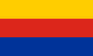 |
Flagge der Provinz Nordholland – flag of the Province of North Holland |
| Die Grafschaft Holland gehörte ab 1299 zu Hennegau, ab 1345 zu Wittelsbach und ab 1433 zu Burgund. Burgund kam 1477 als Erbe zum Haus Habsburg. Es gehörte ab 1579 zur "Utrechter Union" und ab 1581 zur "Republik der Vereinigten Niederlande". Im Jahre 1840 wurde die Provinz Holland in Nord- und Südholland geteilt. Die Flagge der Provinz Nordholland wurde 1958 angenommen. Ihre Farben gehen auf die Wappen der Grafschaft Holland (roter Löwe auf Gold) und der Region Westfriesland zurück (goldene Löwen auf Blau) zurück, deren Farben in dieser Flagge kombiniert werden. |
The County of Holland belonged from 1299 to Hainault, from 1345 to
Wittelsbach and from 1433 to Burgundy. Burgundy came in 1477 as heir to the
House of Habsburg. It belonged from 1579 to the "Union of Utrecht" and from
1581 to the "Republic of the United Netherlands". In 1840 the Province of Holland has been divided in North and South Holland. The flag of the Province of North Holland was adopted in 1958. Its colors go back the arms of the County of Holland (red lion on gold) and of West Friesland (golden lion on blue). Its colors were combined in this flag. |
| Quelle/Source: Wikipedia (D), Flaggen Enzyklopädie, Atlas zur Geschichte, Discovery '97 | |
|
Südholland (South Holland, nied.: Zuid-Holland) |
|
|
Fläche/area: 2.905 km² Einwohner/inh.: 3.470.000 (2008) Hauptstadt/capital: Den Haag |
|
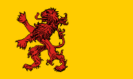 |
Flagge der Provinz Südholland – flag of the Province of South Holland |
|
Die Grafschaft Holland gehörte ab 1299 zu Hennegau, ab 1345 zu Wittelsbach
und ab 1433 zu Burgund. Burgund kam 1477 als Erbe zum Haus Habsburg. Es
gehörte ab 1579 zur "Utrechter Union" und ab 1581 zur "Republik der
Vereinigten Niederlande". Im Jahre 1840 wurde die Provinz Holland in Nord- und Südholland geteilt. Die Flagge der Provinz Südholland wurde 1986 angenommen. Sie zeigt das Abbild des Wappens der Grafschaft Holland, roter Löwe auf Gold. |
The County of Holland belonged from 1299 to Hainault, from 1345 to Wittelsbach and from 1433 to Burgundy. Burgundy came in 1477 as heir to the House of Habsburg. It belonged from 1579 to the "Union of Utrecht" and from 1581 to the "Republic of the United Netherlands". In 1840 the Province of Holland has been divided in North and South Holland. The flag of the Province of South Holland was adopted in 1986. It shows the image of the coat of arms of the County of Holland, a red lion on gold. |
| Quelle/Source: Wikipedia (D), Flaggen Enzyklopädie, Atlas zur Geschichte, Discovery '97 | |
|
Seeland (Zealand, nied.: Zeeland) |
|
|
Fläche/area: 1.790 km² Einwohner/inh.: 381.000 (2008) Hauptstadt/capital: Middelburg |
|
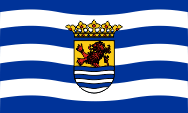 |
Flagge der Provinz Seeland – flag of the Province of Zealand |
| Die Grafschaft Seeland gehörte ab 1345 zu Wittelsbach und ab 1433 zu Burgund. Burgund kam 1477 als Erbe zum Haus Habsburg. Seeland gehörte ab 1579 zur "Utrechter Union" und ab 1581 zur "Republik der Vereinigten Niederlande". Die Flagge der Provinz Seeland wurde 1949 angenommen. Sie zeigt weiße und blaue Wellenlinien und in der Mitte das Wappen der Grafschaft aus dem 15. Jahrhundert. Die Wellenlinien stammen vom unteren Teil des Wappens und sollen in der Flagge den ständigen Wechsel von Wasser und Land im Landschaftsbild der Provinz symbolisieren. Das Wappen ist geteilt und zeigt in der oberen Hälfte die Heraldik Hollands (roter Löwe auf Gold) und in der unteren Hälfte sechs weiße und blaue Wellenlinien. Darüber eine Grafenkrone. |
The County of Zeeland belonged from 1345 to Wittelsbach and from 1433 to
Burgundy. Burgundy came in 1477 as heir to the House of Habsburg. Zeeland
belonged from 1579 to the "Union of Utrecht" and from 1581 to the "Republic
of the United Netherlands". The flag of the Province of Zeeland was adopted in 1949. It shows white and blue wavy lines and in the center the arms of the county from the 15th century. The wavy lines are derived from the lower part of the coat of arms, and should symbolize in the flag the repetitive change of water and land in the landscape of the province. The crest is divided and shows in the upper half of the heraldry of Holland (red lion on gold) and in the lower half six white and blue wavy lines. Above a count's coronet. |
| Quelle/Source: Wikipedia (D), Flaggen Enzyklopädie, Atlas zur Geschichte, Discovery '97 | |
|
Nordbrabant (North Brabant, nied.: Noord-Brabant) |
|
|
Fläche/area: 4.912 km² Einwohner/inh.: 2.430.000 (2008) Hauptstadt/capital: Herzogenbusch |
|
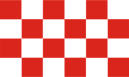 |
Flagge der Provinz Nordbrabant – flag of the Province of North Brabant |
| Nordbrabant ist der früher auch Generalitätslande genannte Norden es ehemaligen Herzogtums Brabant, der erst 1648 zur "Republik der Vereinigten Niederlande" kam. Der Süden von Brabant liegt heute zwischen Flandern und Wallonien aufgeteilt in Belgien. Brabant wurde 1355 Luxemburgischer Besitz, 1436 Burgundischer Besitz und kam 1555 als Erbe an das Haus Habsburg. Das Wappen von Brabant zeigt einen rotbewehrten goldenen Löwen auf Schwarz, der in Belgien auch auf den Brabanter Flaggen verwendet wird. Die 1958 eingeführte Flagge von Nordbrabant geht auf eine Flagge zurück, die im 17. Jahrhundert vom Herzogtum Brabant verwendet wurde. |
North Brabant – previously also called Generality Lands – is the north of
the former Duchy of Brabant, which came to the "Republic of the United
Netherlands" not until 1648. The south of Brabant is now placed in Belgium
and splited between Flanders and Wallonia. Brabant became in 1355 a
possession of Luxembourg, in 1436 a Burgundian possession and came in 1555
as heir to the House of Habsburg.
The coat of arms of Brabant shows a red armed golden lion on black, which is
used in Belgium on the flags of Brabant. The flag of North Brabant was
introduced in 1958, and goes back to a by the Duchy of Brabant used flag of
the 17th century. |
| Quelle/Source: Wikipedia (D), Flaggen Enzyklopädie, Atlas zur Geschichte, Discovery '97 | |
| Limburg | |
|
Fläche/area: 2.169 km² Einwohner/inh.: 1.123.000 (2008) Hauptstadt/capital: Maastricht |
|
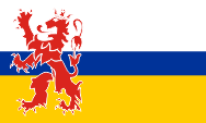 |
Flagge der Provinz Limburg – flag of the Province of Limburg |
| Das ehemalige Herzogtum Limburg wurde 1355 Luxemburgischer Besitz, 1406 Burgundischer Besitz und kam 1555 als Erbe an das Haus Habsburg. In der Provinz Limburg wurden nach dem Wiener Kongress von 1815 das Territorium von Limburg mit Gebieten von Obergeldern, Lüttich und Jülich vereinigt. Das Wappen von Limburg zeigte einen gekrönten, roten Löwen auf weißem Grund. Der Löwe und auch Weiß tauchen auf der Flagge der Provinz Limburg auf, aber auch ein zentraler blauer Streifen, der den Fluss Maas symbolisiert, und ein goldener Streifen, der an das Gold in den Wappen von Jülich, Geldern, Hoorn und Valkenburg erinnern soll. Die Flagge wurde 1953 eingeführt. |
The former Duchy of Limburg became in 1355 a Luxembourg possession, and in
1406 a Burgundian possession, and came in 1555 as heir to the House of
Habsburg. In the Province of Limburg were united – after the Vienna
Convention of 1815 – the territory of Limburg with areas of Upper Geldern,
Liege and Julich. The coat of arms of Limburg showed a crowned red lion on a white background. The Lion and also white appear on the flag of the province of Limburg, but also a central blue stripe, which symbolizes the river Maas, and a golden stripe, to commemorate the gold in the arms of Julich, Geldern, Hoorn and Valkenburg. The flag was introduced in 1953. |
| Quelle/Source: Wikipedia (D), Flaggen Enzyklopädie, Atlas zur Geschichte, Discovery '97 | |
|
Staatsflandern (State-Flanders, Zealand-Flanders, nied.: Zeeuws-Vlaanderen) |
|
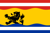 |
Flagge von Staatsflandern – flag of Zeeuws-Vlaanderen |
| Staatsflanden ist keine Provinz. Es ist der Teil des Territoriums der alten Grafschaft Flandern, der heute in den Niederlanden liegt, im Süden der Provinz Seeland, im Gebiet der drei Gemeinden Terneuzen, Sluis und Hulst. Hier wird seit 2009 eine eigene Flagge verwendet. Sie ist das gemeinsame Symbol der drei Gemeinden und zeigt neun Streifen in rot-weiß-rot-gelb-blau-weiß-blau im Verhältnis 1:1:1:6:1:1:1. Im gelben Streifen, in Richtung Mast verschoben, befindet sich der schwarze Löwe von Flandern der auch im Wappen von Hulst erscheint. Auf die traditionell rote Bewehrung (Zunge und Krallen) wurde bewusst verzichet, um den Löwen "junger, robuster und dynamischer" aussehen zu lassen. Die oberen roten Streifen stammen von der Flagge von Sluis, während die unteren blauen Streifen von der Flagge von Terneuzen stammen. |
State-Flanders is not a
province. It is the part of the territory of the old County of Flanders that
is nowadays placed in the Netherlands, in the south of the province of
Zealand, in the area of the three municipalities Terneuzen, Sluis and Hulst.
Here an own flag is in use since used since 2009. It is the common symbol of the three communities and shows nine stripes in red-white-red-yellow-blue-white-blue in a ratio of 1:1:1:6:1:1:1. In the yellow stripe, moved towards the mast, appears the black lion of Flanders, which also appears in the coat of arms of Hulst. The traditional red reinforcement (tongue and claws) of the lion was deliberately omitted in order to make the lion look "younger, more robust and more dynamic". The upper red stripes come from the flag of Sluis, while the lower blue stripes come from the flag of Terneuzen. |
| Quelle/Source: Wikipedia (NL) | |